
Contents
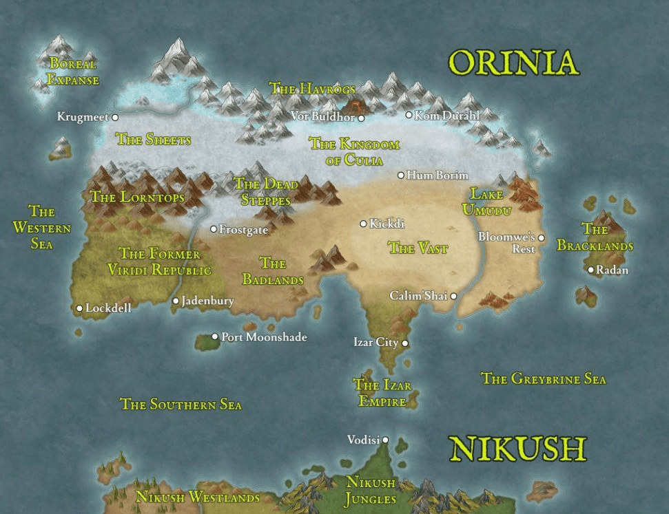
Map of The Known World
Orinia:
The northernmost continent of the known world, Orinia is home to three major human countries: Viridia, Culia, and Izar. Krugen tribes make their homes in the northwestern mountains and the Sheets, sometimes going to war with human civilization.
Nikush:
The southern continent of Nikush remains largely unexplored by the humans of Orinia. Only the Izari Empire has managed to colonize the northern peninsula, but disease and worse prevent advanced civilization from expanding too far south.
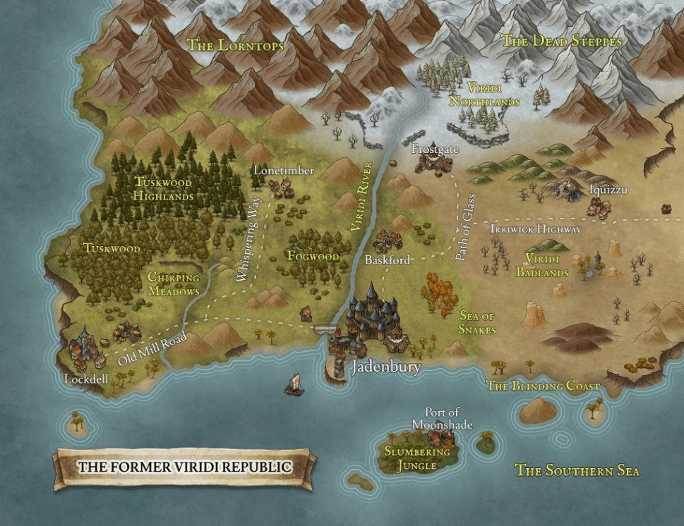
Map of The Former Viridi Republic
The Former Viridi Republic:
Once a bastion of human discourse and philosophy, the Viridi Republic has recently fallen into political turmoil and civil war. It lies south of the Lorntop Peaks and Dead Steppes, on the coast of the Southern Sea.
Lockdell:
Nestled in the cliffs above the Southern Sea, Lockdell is a mid-sized settlement surrounded by farms and timberland. It has always been a target for bandits from Tuskwood and the foothills of the Lorntops.
Tuskwood:
Prime hunting ground for juicy boar, Tuskwood spans from Lockdell into the foothills. Recently, the Bearded Bandits have taken up residence in these woodlands.
Old Mill Road:
This road links Lockdell to the capital city of Jadenbury to the east. Bandits and krug raiders often waylay caravans along the way
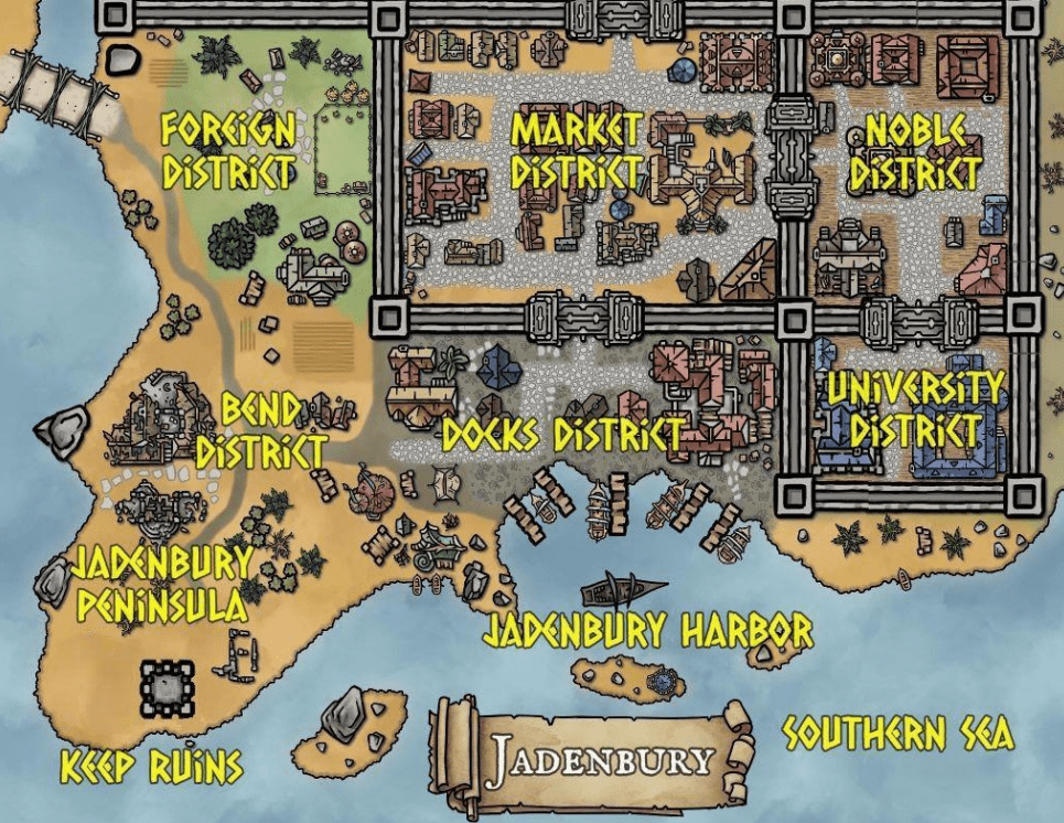
Map of Jadenbury
Foreign and Docks Districts:
Refugees, mercenaries, and aspiring merchants make their homes outside the walls of the city. These areas are particularly rife with crime.
Riverfoot Keep Ruins:
Constructed by the Lavani Dynasty nearly two millennia ago, the ruins of Riverfoot keep overlook the waves of the Southern Sea on the cliff of the peninsula, outside the modern city’s walls.
Market and Noble Districts:
The wealthy nobles and merchants that live behind the walls of the capital know that their privilege during this civil war hangs by a thread. Only a select few are allowed through one of the two gates.
Jadenbury University:
Constructed over a thousand years ago after the discovery of gemcracks, this university is home to the greatest academic minds Viridia has to offer.
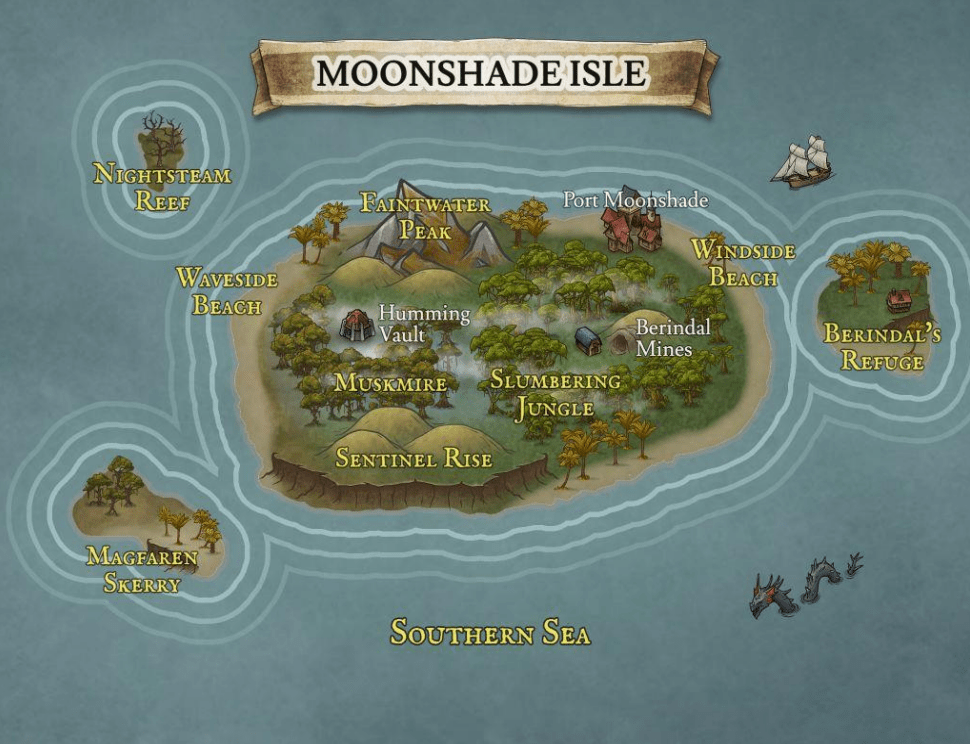
Map of Moonshade Island
Moonshade Isle:
Colonized by the Viridians around 700 years ago, the tropical isle of Moonshade produces exotic fruits, silver, and more recently the dangerous drug known as moonlight, a flower smuggled on to the mainland by the Third Moon Pirates, as well as other groups.
Port Moonshade:
The main settlement of the island is on the north side. Though the slave trade was outlawed by the Republic, it still persists, and it is an open secret that certain locales partake in the business.
Slumbering Jungle:
The Slumbering Jungle probably gets its name from moonlight flowers, which cause drowsiness and euphoria when its pollen is inhaled. When refined, these flowers are a dangerous drug. In a clearing deep within the jungle lie the mines of the silver magnate, Berindal.
Berindal’s Refuge:
The vacation resort islet of the silver magnate, Berindal, this refuge is highly defended and very luxurious.
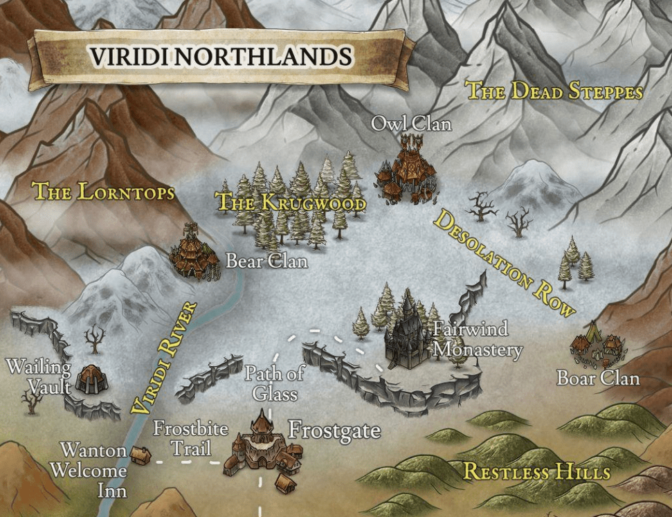
Map of The Viridi Northlands
Frostgate:
Frostgate is a rather large settlement that sits on the snowline of the Viridi Northlands, along the Path of Glass. The Dead Steppes separate this northern reach of Viridia from the Kingdom of Culia, far to the northeast. Viridi citizens here are mostly miners and hunters, but there is also sparse farmland.
Wanton Welcome Inn:
This cozy little inn rests near the northern stretch of the Viridi River. It serves as an outpost for people trading with the krugen tribes.
Fairwind Monastery:
This quiet monastery is dedicated to the four lesser gods: Veela, Theela, Rokos, and Balos. There is an empty chapel dedicated to the two silent greater gods, but it is taboo to enter. The krugen clans generally leave it be as it holds no worldly treasures.
Krugen Clans:
The Boar Clan, Wolf Clan, and Owl Clan all make their homes in the Viridi Northlands. The Owl Clan was the only one to sign a trade agreement with the Viridi Republic, before its downfall. What the krugens plan now that the republic has collapsed is a mystery.
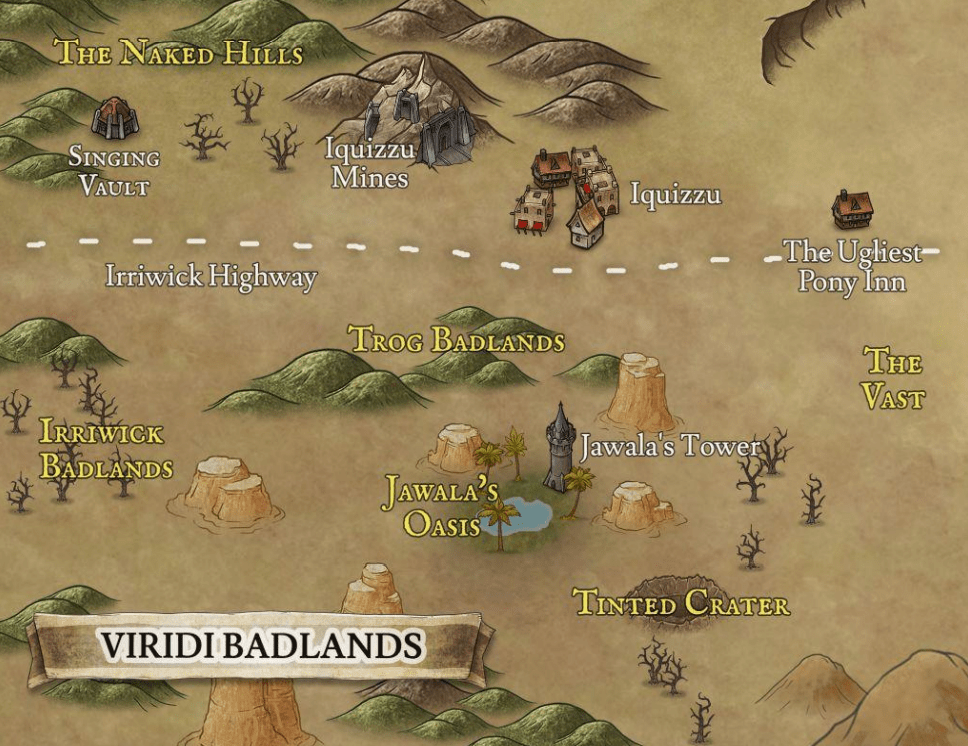
Map of The Viridi Badlands
Iquizzu:
Though named after the subterranean troglodyte colony in the nearby cliffs, the surface town was established as a trade post by Viridi humans, and humans make up roughly half the population. Almost all steel used by the humans of the former Viridi Republic is trog steel.
Jawala’s Oasis:
The famed Izari biomancer, Jawala the Bloodmaker, makes this oasis her home. In her quest to eradicate death, she has used the Arts and her influence to create an impenetrable tower to study in solitude.
Tinted Crater:
Records do not speak of when this great hole in the earth was formed, but experts say it was the result of an impact from a rock from the stars. No one dares approach lest they become deathly ill.
The Ugliest Pony Inn:
The final resting stop before the Great Vast, the Ugliest Pony Inn was managed by House Mesali before the civil war. Since that time, it has changed hands several times.
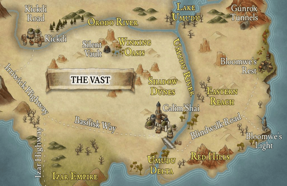
Map of The Vast
The Vast:
Home now only to wandering nomads and shifting sands, the Vast is a massive swathe of desert in southeastern Orinia that hides ancient ruins.
Calim’Shai:
The Jewel of the Desert, Calim’Shai remains an independent citystate run by wealthy merchants. It trades frequently with the three major human kingdoms, but the harsh and unforgiving climate alone is enough to ensure its independence. It sits on the west bank of the Umudu River.
Kickdi:
A town on the highway between the Kingdom of Culia and the Former Viridi Republic, Kickdi often changes hands. It was controlled by House Mesali of the Former Republic until the recent civil war. It is renown for its brothels and bathhouses.
Bloomwe’s Rest:
A small town on the eastern coast of the Orinia, this settlement has managed to cultivate a fair amount of land despite the dry climate. The road stretches south to the the lighthouse known as Bloomwe’s Light, and north to the subterranean trog colony of Gunrox.
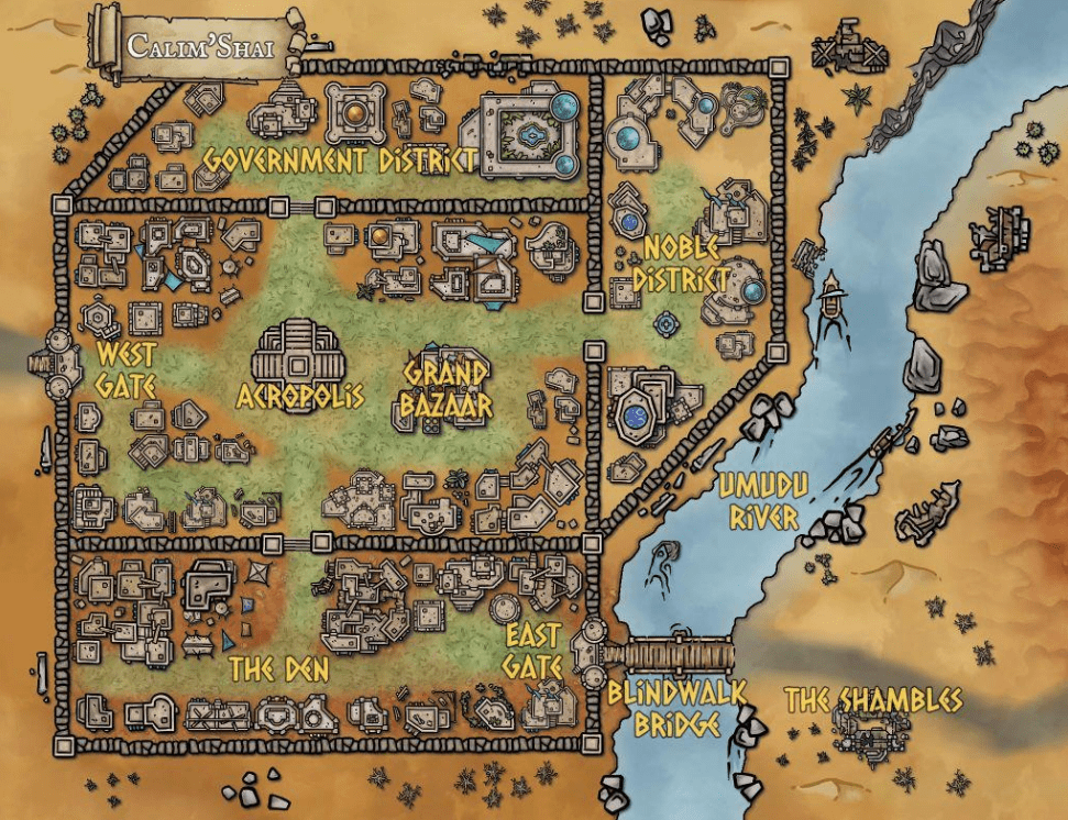
Map of Calim’Shai
Calim’Shai:
The Jewel of the Desert, Calim’Shai is an independent city-state run by wealthy aristocrats, mostly from the Izar Empire and the former Viridi Republic. It is defended by the prestigious mercenary group the White Sabers.
Acropolis:
The highest point of the city is the Temple of Aona, the Godling of finance and trade. The High Priest lived and works here, and acts as the figurehead of the city, though everyone knows the merchants wield the real power. Most commoners in Calim’Shai are highly religious and revere the Viridi pantheon.
The Den:
The southern district of the city is called the Den, inhabited mostly by slaves of the Temple. The slaves here have more autonomy than most, being separated from their masters more often than not. The district is extremely dangerous at night.
The Shambles:
The shambles is a group of nomads who make their home outside the walls of Calim’Shai, across the Blindwalk Bridge to the southeast.
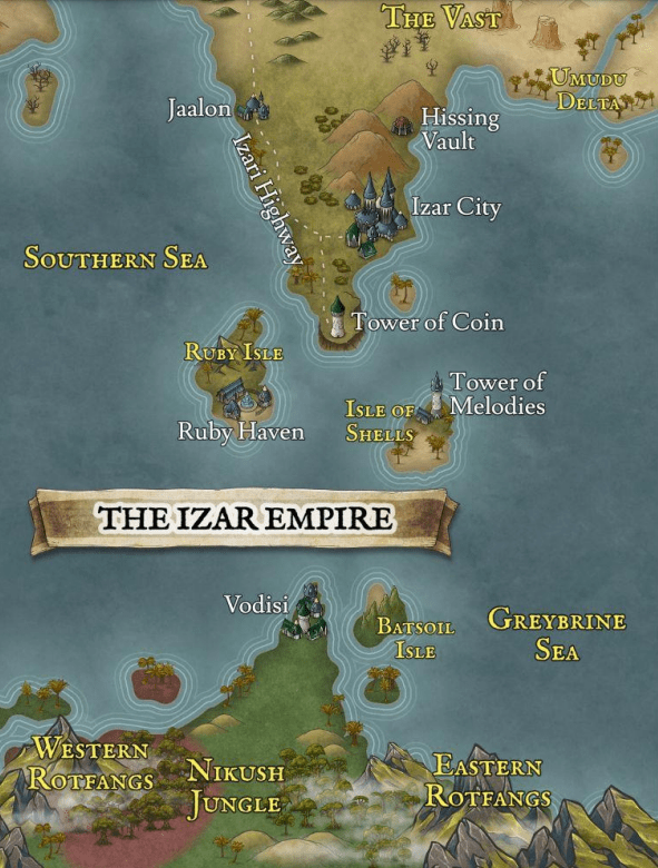
Map of The Izar Empire
The Izar Empire:
Spanning two continents, the seafaring Izari people are master traders. Their soft power usually keep them out of full-scale wars with the other human countries, and currently their main concern is expanding south in the continent of Nikush.
Izar City:
The capital of the Izari Empire and one of the oldest cities in Orinia. It is the throne of First Man Malik, who the Izari believe has the divine right of kings, passed on from
Ruby Isle:
The luxurious vacation resort of only the wealthiest Izari nobility.
Isle of Shells:
The greatest musicians in Orinia make pilgrimages here to learn at the Tower of Melodies. Along with the Tower of Coin and Ruby Isle, this jewel of the empire is heavily defended by the Izari navy.
Jaalon:
A small port on the Izari Highway. It serves mostly as a rest stop for merchants on both ship and foot.
Vodisi:
A small Izari settlement on the peninsula on the north coast of the continent of Nikush. Vodisi stands as a bastion of civilization in the deadly jungles of the southern continent.
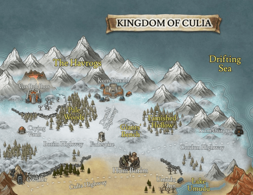
Map of The Kingdom Of Culia
The Kingdom of Culia:
The frozen north is home to more than just krugen barbarians. The Kingdom of Culia claims the oldest human lineage on the continent, and their ancient stone fortresses and runic inscriptions are testament to this.
Fadespire:
The southernmost Culian defense outpost, this tower watches roads leading four directions: north to the capital of Kom Durahl, east to Lake Umudu, south the Vast, and west to Dug Olihm.
Hum Borim:
The largest city of the Kingdom of Culia, Hum Borim is sits along the Culian Highway on the northern edge of the Great Vast.
Kom Durahl:
The Culian capital and northernmost city, Kom Durhal is built into the Havrog Mountains, and its denizens claim it to be the oldest city in Orinia.
Lake Umudu:
A tiny fishing village near Lake Umudu, near the Vast.
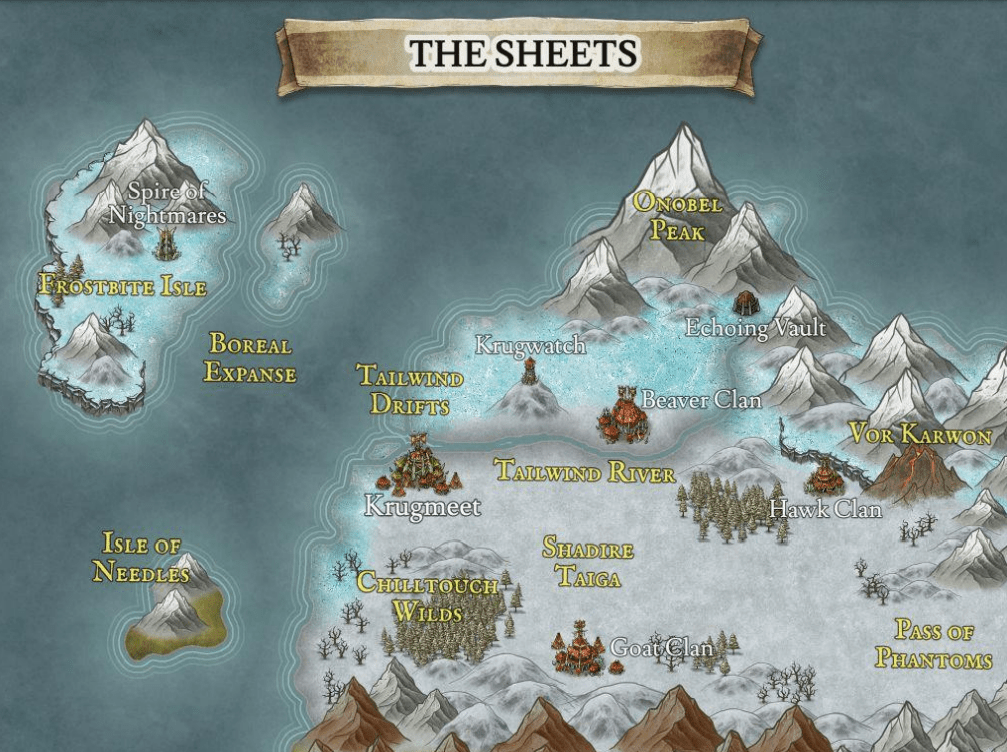
Map of The Sheets
Pass of Phantoms:
This haunted pass is the easiest way to access the land of the krugen and the Sheets. The legends of the ghosts here are probably nothing more than tricks of the wind echoing off the sheer icy cliffs.
Krugmeet:
The chiefs of most krugen clans, of which there are hundreds spread across the Shadire Taiga and nearby mountains, meet in this ramshackle settlement on the frozen northwestern coast of Orinia. The clans tolerate each other, but humans and non-krugen are either killed on sight or taken as slaves.
Vor Karwon:
This ancient and solitary volcano fortress is said to have been constructed by the Kingdom of Culia untold millennia ago. The gods and runes depicted on its black walls have been all but forgotten to the humans of southern Orinia, and its inhabitants are known only to the Culians.
Onobel Peak:
The highest mountain in Orinia, Onobel Peak is inhabited mostly by krugen, eberan, lupulus, and other bestial species.
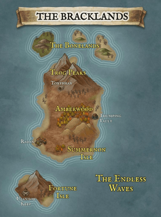
Map of The Bracklands
The Bracklands:
The islands east of Orinia are home mostly to troglodytes, pirates, and exiles. Storms ravage the shores, and the undead are not an uncommon sight. The largest island is Summernon Isle, home to the only human settlement, Radan.
Radan:
Radan is a small independent city that pays tribute to several pirate captains. The surrounding farmlands are sparse but vital, and most denizens survive on the bounty of the sea.
Ulantor Keep:
This doomed keep is sometimes inhabited, sometimes abandoned. Rumors among the plebs say it is haunted, cursed, or both.
Amberwood:
North of Radan, Amberwood was once noted for the rich gold deposits, but for the last twenty years the dead have risen to attack anyone who dares prospect the hills. Rumor has it that trog necromancers are to blame.
Toxthrax:
An underground troglodyte city where necromancy is practiced. Brackland trogs are particularly hostile to human civilization.
Be the first to comment